
Sidman's Bridge
A Brief Account of the History of the Fortifications at Ramapo, New York during the American Revolution
Kenneth R. Rose
[Editor's Note: This article appeared in the 1989 Issue of the Journal of the Orange County Historical Society (No. 18). It is being republished on the website as part of the ongoing activities surrounding the 250th Anniversary of the Revolutionary War. The footnoted version is contained in the 1989 Journal which is available for purchase. The original article contained no illustrations. All of the illustrations and their captions in this on-line version were added by the editor. JAC]
Part I:
Introduction
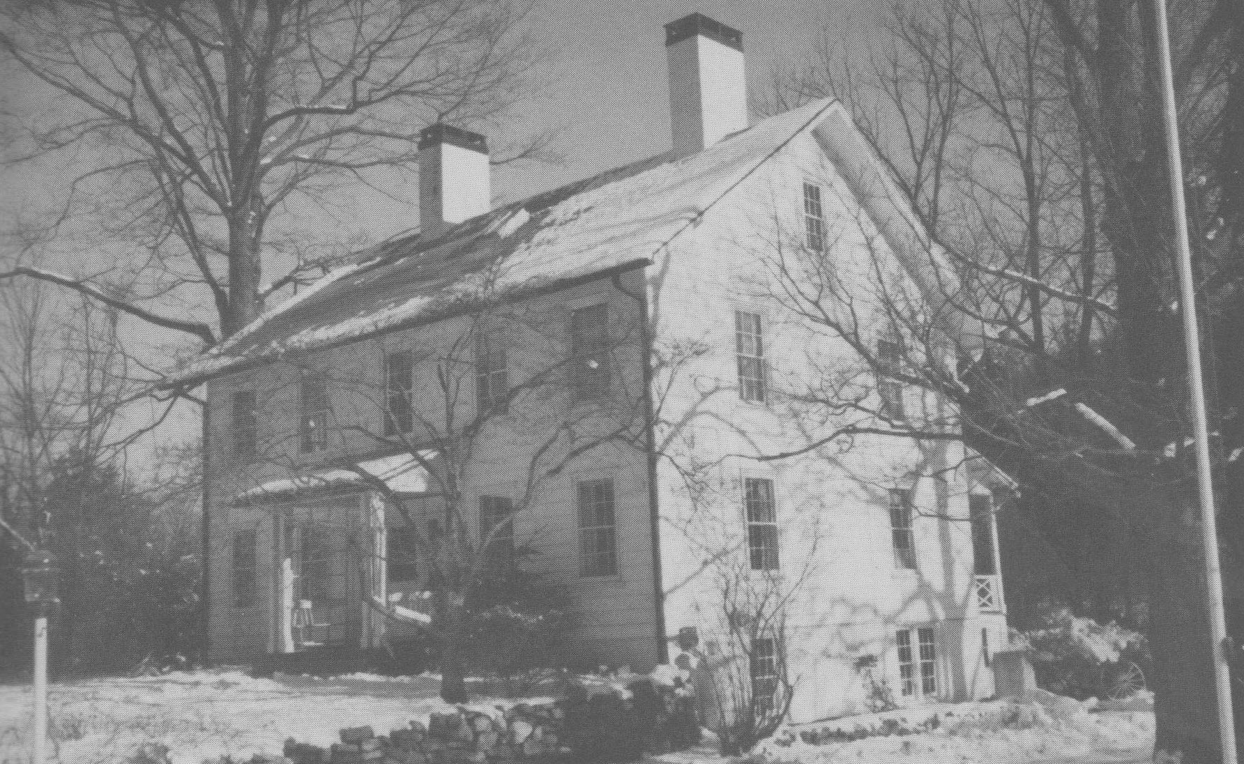 Sidman's Tavern. Route 17 skirts the easterly side of the knoll in which the Van Deusen-Sidman tavern stood, and bypasses the old Clove Road slightly to the west. Pinned oak timbers attest to the age of the frame building on the site, the northerly part of which is believed to be part of the 18th-century hostelry. John G. Smith, who married Sidman's daughter prior to 1789, succeeded his father-in-law as the tavern proprietor, and about 1816 added about twelve feet to the building. It continued in Smith ownership until acquired by the Pierson family later in the 19th-century. This photograph taken in 1988 by Claire Tholl shows the west front of the building which faced the Revolutionary War road.
The short account which follows is intended to give the reader an overview of the history of the Revolutionary fortifications at Sidman's Bridge rather than a chronology of the events which took place there throughout the war. Its purpose is to describe the fortifications and the physical changes that occurred in them during the war; the military objectives to be achieved by placing a fortification at the entrance of the Ramapo Pass; the troops, both Continental and militia units, which occupied the garrison during the years 1776-83; and to give a few highlights of the history of the fortification during this period.
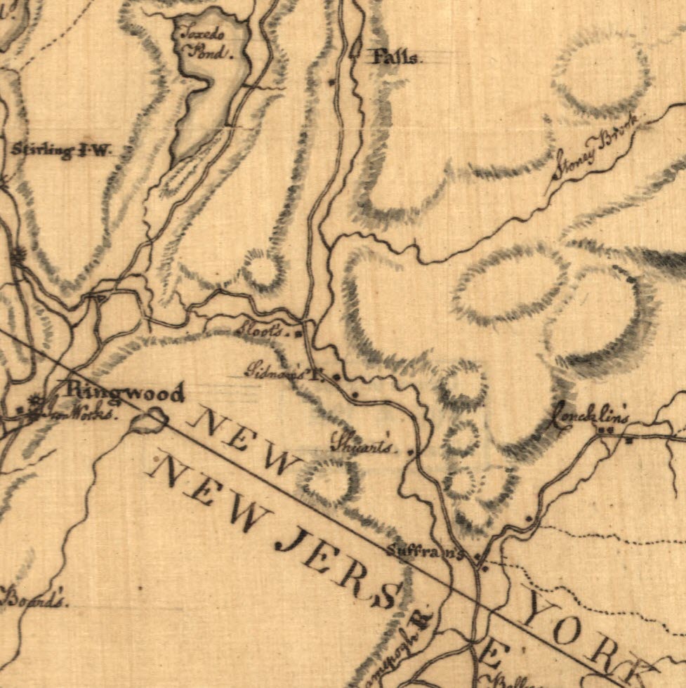 Map of Orange and Rockland counties area of New York Detail of a manuscript map drawn by Robert Erskine (1735-1780), Geographer General of the Continental Army. Retrieved from the Library of Congress, https://www.loc.gov/item/gm71002215/. This image is a portion of this map showing the location of the entrance to the Ramapo Pass. The Ramapo River is the curvy line that flows from the top of the image to the bottom. The straighter line that follows the river was the road through the mountains of the "Highlands" which had several names including "The Clove Road." At the bottom of the map, near the NY/NJ border, is Suffran's (Suffern's) Tavern at the current location of Suffern, NY. The next label to the north on the River is "Shuart's." Koke describes this structure as a small home (not a tavern). Shuart's is located right where the road crosses the river, the site of the bridge. Yet, Samuel Sidman's Tavern was so well known that the general area became known as Sidman's Clove and the river crossing as "Sidman's Bridge." The next label up the River is Sidman's Tavern. See Koke Article. Just to the north of Sidman's is Sloot's (Sloat or Slot) and the location of current Sloatsburg, NY. Labeled to the left is the Ringwood Ironworks. Click on the image to enlarge.
The original (1776-77) Sidman fortifications consisted of two fosse [ditches], one stretching from the east side of the Ramapo Pass just south of the Black Bridge over the Ramapo River running in a westerly direction to the base of Little Mountain on which Mount Fuji restaurant now stands [see Marker 3 below], with the second crossing the present Route 17 from the west side of this hill to the mountains on the west wide of the Pass [see Marker 7 below]. .
 LOWER ENTRANCE TO SMITH'S CLOVE sometimes called Sidman's Clove and later the Ramapo Pass. 1. Site of John Suffern's tavern, northwest corner of Washington and Lafayette avenues, Suffern. 2. Sidman's Bridge across the Ramapo River. 3. Line of American entrenchment, constructed November 1776 between the mountain and Ramapo River, as indicated on R. E. O'Connor map of Rockland County, 1854. 4. Tablet, 1922, Torne Valley Road, marking Ramapo entrenchment. 5. Former Ramapo Presbyterian Church and graveyard, junction of Routes 17 and 59. Approximate site of "Little redoubt" of 1776, the "old fort" depicted on Erskine maps and the blockhouse of 1781-83. The Revolutionary War barracks for the Sidman garrison were probably also in this area. 6. Site of Shuart's house, Route 59, American Revolution. 7. Fox Hollow Tablet, 1904, Route 17, Hillburn, commemorating the post at Ramapo. 8. Ramapo Works, important 19th-century industrial village, now vanished, established 1795 by Josiah and Jeremiah Pierson on land purchased from John Suffern.
The fieldwork would, in the tradition of the day, have been a breastwork, probably of gabions filled with earth or constructed of packed earth surmounted by a headlog, raised just high enough to allow a musket to be inserted between it and the lower work.
A small redoubt was constructed on a site presently occupied by the New York State Thruway and stood for several years as a part of the defenses. The redoubt was later leveled and a two story blockhouse was constructed, on its site, which remained for years after the war. [See Marker 5 above]
These fieldworks were protected in much the same manner as most field fortifications of the time by abatis and chevaux-de-frise. Of course, fields of fire were cleared of trees and vegetation, with the trees felled in the direction from which the enemy would approach so that the sharpened branches would be an additional hindrance to forward movement in an attack. For added security against the forays of the enemy, Picquet Posts were placed along the line of an enemy's advance at a distance of approximately one half mile from the fortifications. These were assisted during the hours of daylight by lookout posts stationed on advantageous terrain features. In addition to these measures patrols, either mounted or on foot, would have been sent out to reconnoitre and gather intelligence on the movements of any enemy
As one considers the actual location of the fortifications at Sidman's Bridge in light of the geography of the Clove it immediately strikes the observer that instead of encompassing the dominant geographic feature which controlled the tactical situation (Little Mountain), it attempted to run through the center of it. Why didn't the plan of the fortifications place this dominant terrain feature within the immediate confines of the area fortified? It is most likely that consideration of the manpower available measured against the objectives to be achieved that warranted the positioning of the fortifications where it is, rather than developing a more secure position which would have required a much larger number of men to effectively garrison such an extended line of fortifications. It should be remembered when considering the Sidman's fortifications that within certain limits, embracing most types of field fortifications, that the elements of defensive strength are determined more by the environment and approaches than by the dimension, trace, and relief of the work itself."
The fortifications at Sidman's Bridge were constructed to fulfill three objectives. First, it provided an effective means of early warning should the enemy attempt to gain the rear of the American positions in the Highlands by a flanking movement via the Ramapo Pass and New Windsor. Second, the fortifications served to protect the lines of communication between the main army under General Washington and the forces stationed in the Hudson Highlands. Third, the forces stationed at Sidman's made intercourse more difficult between the Orange County Tories and their allies in the neutral ground of Bergen County, New Jersey.
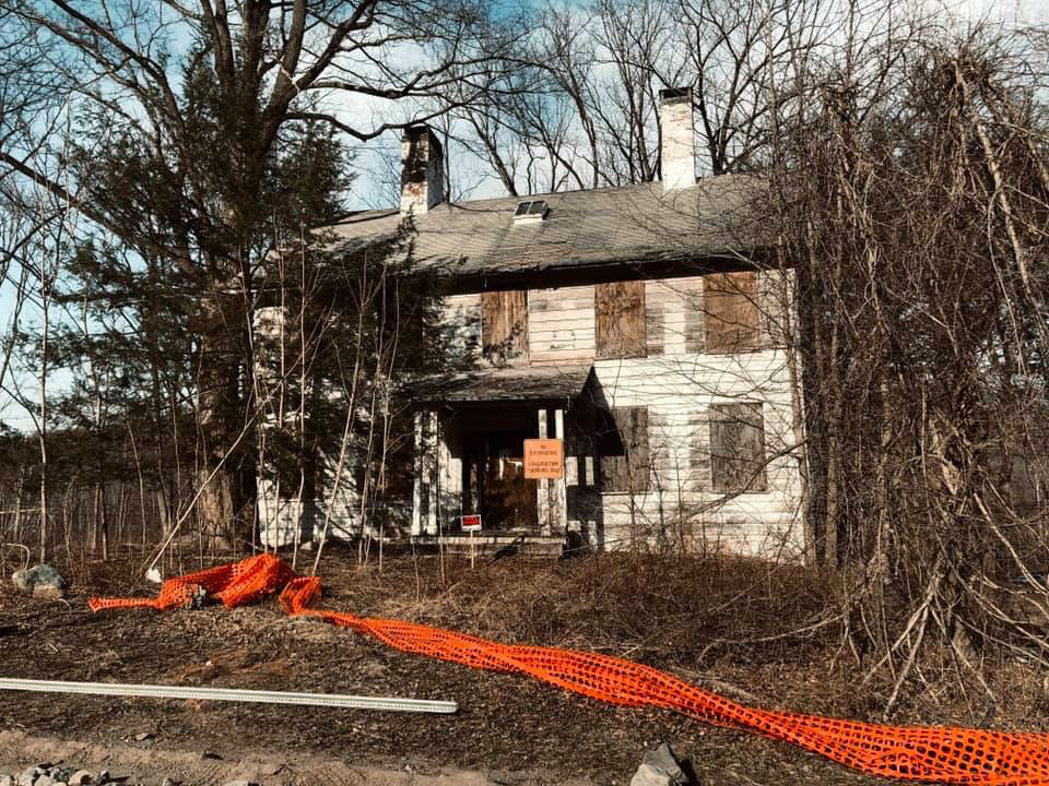 Sidman's Tavern Ruins Today
Gabriel Neville, The Last Vestige of the Clove Road, Journal of the American Revolution, July 16, 2019.
Next Issue of Journal!
The Next Issue of the OCHS Journal is now accepting articles for consideration.
Authors
More guidelines for authors
Classics from the Journal
NEW!! General Richard Montgomery - Hero of Two Nations
by Marc Newman
NEW!! Joseph Brant and the Battle of Minisink
by Donald F. Clark
NEW!! John Hathorn - American Patriot
by Richard W. Hull
The New Windsor Artillery Park, 1780-1781 - Part I
by Michael S. McGurty
The New Windsor Artillery Park, 1780-1781 - Part II
by Michael S. McGurty
Orange County Militia During the American Revolutionary War
by Alan Aimone
George Washington's Masonic Activities in Orange County
by Andrew J. Zarutskie
Prisoners of War in Goshen
by Harold J. Jonas
John Robinson of Newburgh
by Margaret V. S. Wallace
The Battle of Fort Montgomery
by Donald F. Clark
Role of Regional Revolutionary Women
by Michelle P. Figliomeni
Robert R. Burnet (1762-1854)- The Last Continental Officer
by Alan C. Aimone and Barbara A. Aimone
The Revolutionary Soldier in Washington's Army
by Edward C. Cass
Technical Communication in the Amercan Revolution
by Carol Siri Johnson
New Windsor Cantonment
by E. Jane Townsend
Sidman's Bridge
by Kenneth R. Rose
Corridor Through the Mountains
by Richard Koke
Lydia Sayer Hasbrouck and "The Sybil"
by Amy Kesselman
The Store at Coldengham (1767-1768)
by Jay A. Campbell